
Credits: NASA/JPL-Caltech
One of the most successful and enduring feats of interplanetary exploration, NASA’s Opportunity rover mission is at an end after almost 15 years exploring the surface of Mars and helping lay the groundwork for NASA’s return to the Red Planet.
The Opportunity rover stopped communicating with Earth when a severe Mars-wide dust storm blanketed its location in June 2018. After more than a thousand commands to restore contact, engineers in the Space Flight Operations Facility at NASA’s Jet Propulsion Laboratory (JPL) made their last attempt to revive Opportunity Tuesday, to no avail. The solar-powered rover’s final communication was received June 10.
Designed to last just 90 Martian days and travel 1,100 yards (1,000 meters), Opportunity vastly surpassed all expectations in its endurance, scientific value and longevity. In addition to exceeding its life expectancy by 60 times, the rover traveled more than 28 miles (45 kilometers) by the time it reached its most appropriate final resting spot on Mars – Perseverance Valley.
The final transmission, sent via the 70-meter Mars Station antenna at NASA’s Goldstone Deep Space Complex in California, ended a multifaceted, eight-month recovery strategy in an attempt to compel the rover to communicate.
Opportunity landed in the Meridiani Planum region of Mars on Jan. 24, 2004, seven months after its launch from Cape Canaveral Air Force Station in Florida. Its twin rover, Spirit, landed 20 days earlier in the 103-mile-wide (166-kilometer-wide) Gusev Crater on the other side of Mars. Spirit logged almost 5 miles (8 kilometers) before its mission wrapped up in May 2011.
From the day Opportunity landed, a team of mission engineers, rover drivers and scientists on Earth collaborated to overcome challenges and get the rover from one geologic site on Mars to the next. They plotted workable avenues over rugged terrain so that the 384-pound (174-kilogram) Martian explorer could maneuver around and, at times, over rocks and boulders, climb gravel-strewn slopes as steep as 32-degrees (an off-Earth record), probe crater floors, summit hills and traverse possible dry riverbeds. Its final venture brought it to the western limb of Perseverance Valley.
“I cannot think of a more appropriate place for Opportunity to endure on the surface of Mars than one called Perseverance Valley,” said Michael Watkins, director of JPL. “The records, discoveries and sheer tenacity of this intrepid little rover is testament to the ingenuity, dedication, and perseverance of the people who built and guided her.”
– NASA Press Release, February 13, 2019, Editor: Karen Northon
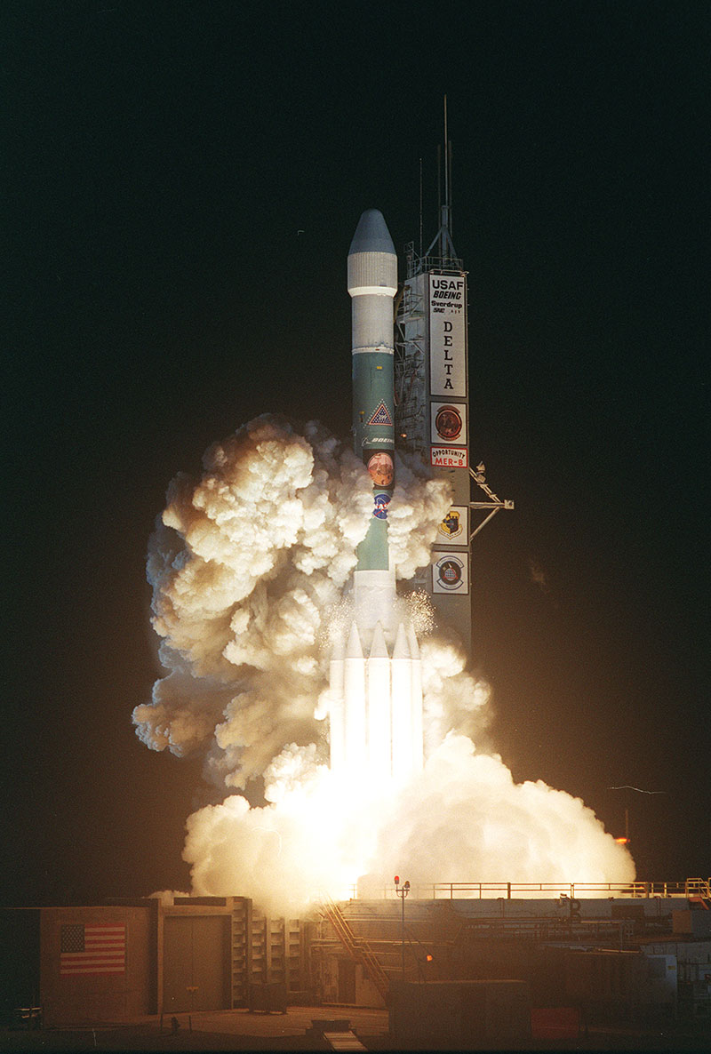
Image Credit: NASA
On July 7, 2003, NASA launched its second Mars Exploration Rover, Opportunity, aboard a Delta II launch vehicle. Opportunity’s dash to Mars began with liftoff at 11:18:15 p.m. EDT from Cape Canaveral Air Force Station, Florida. The spacecraft separated successfully from the Delta’s third stage 83 minutes later, after it had been boosted out of Earth orbit and onto a course toward Mars. Opportunity and its twin rover Spirit landed on Mars in 2004 to begin missions planned to last three months.

Image credit: NASA/JPL/Cornell
As NASA’s Mars Exploration Rover Opportunity creeps farther into “Endurance Crater,” the dune field on the crater floor appears even more dramatic. This false-color image taken by the rover’s panoramic camera shows that the dune crests have accumulated more dust than the flanks of the dunes and the flat surfaces between them. Also evident is a “blue” tint on the flat surfaces as compared to the dune flanks. This results from the presence of the hematite-containing spherules, or “blueberries”, that accumulate on the flat surfaces.
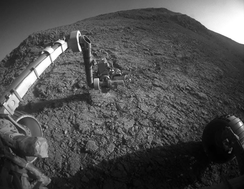
Image Credit: NASA/JPL-Caltech
The target beneath the tool turret at the end of the rover’s robotic arm in this image from NASA’s Mars Exploration Rover Opportunity is “Private John Potts.” It lies high on the southern side of “Marathon Valley,” which slices through the western rim of Endeavour Crater. The target’s informal name refers to a member of the Lewis and Clark Expedition’s Corps of Discovery.
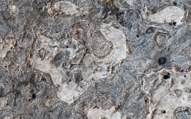
Image credit: NASA/JPL-Caltech/Univ. of Arizona
NASA’s Opportunity rover has spent 13 years exploring a small region of Meridiani Planum which has a rather ordinary appearance as seen by NASA’s Mars Reconnaissance Orbiter (MRO). Other portions of Meridiani are much more interesting, with well-exposed layered bedrock eroded into strange patterns.

Image Credit: NASA/JPL-Caltech/Univ. of Arizona
This map show a portion of Endeavour Crater’s western rim that includes the “Marathon Valley” area investigated intensively by NASA’s Mars Exploration Rover Opportunity in 2015 and 2016, and a fluid-carved gully that is a destination to the south for the mission.
The width of the area covered in the map is about half a mile (about 800 meters). North is up. Opportunity entered the northern end of the mapped area in January 2015 and entered Marathon Valley in July 2015. A gold line on the map, which may not be visible without zooming into the image, shows the rover’s route. Opportunity departed Marathon Valley in September 2016 by driving southward through “Lewis and Clark Gap” into “Bitterroot Valley.”
The gully near the south end of the map was incised into Endeavour’s rim long ago by a fluid, possibly a water-lubricated debris flow or a flow with mostly water. Driving into this gully to learn more about that flow is one of the goals for a two-year mission extension taking Opportunity through September 2018.

Image Credit: NASA/JPL-Caltech/Cornell Univ./Arizona State Univ.
This view from NASA’s Mars Exploration Rover Opportunity shows part of “Marathon Valley,” a destination on the western rim of Endeavour Crater, as seen from an overlook north of the valley. In this version of the image, the landscape is presented in false color to make differences in surface materials more easily visible.

Image Credit: NASA/JPL-Caltech
The Mars Exploration Rover Opportunity has eyed an oddly shaped, dark rock, which may be a meteorite and is about 2 feet across, on the surface of the Red Planet on July 18, 2009. The team spotted the rock called ‘Block Island’ in the opposite direction from which it was driving. The rover then backtracked some 820 feet to study it closer. Scientists will test the rock with the alpha particle X-ray spectrometer to get composition measurements and to confirm if indeed it is a meteorite.
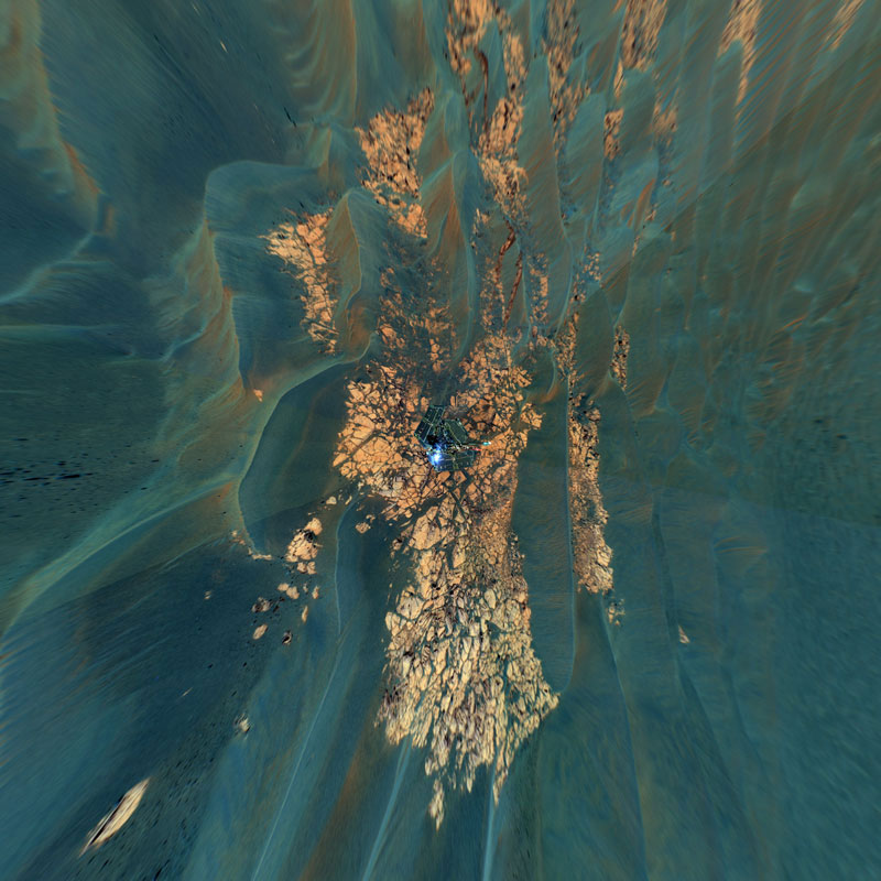
Image credit: NASA/JPL-Caltech/Cornell
This false-color view combines frames taken by the panoramic camera on NASA’s Mars Exploration Rover Opportunity on the rover’s 652 through 663 Martian days, or sols (Nov. 23 to Dec. 5, 2005), at the edge of Erebus Crater. The mosaic is presented as a vertical projection. This type of projection provides a true-to-scale overhead view of the rover deck and nearby surrounding terrain. The view here shows outcrop rocks, sand dunes, and other features out to a distance of about 25 meters (82 feet) from the rover.
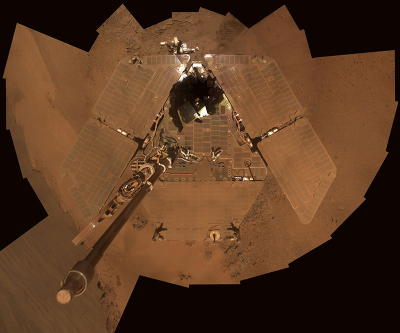
Image Credit: NASA/JPL-Caltech/Cornell/Arizona State Univ.
This self portrait from NASA’s Mars Exploration Rover Opportunity shows dust accumulation on the rover’s solar panels as the mission approached its fifth Martian winter. The dust reduces the rover’s power supply, and the rover’s mobility is limited until the winter is over or wind cleans the panels. This is a mosaic of images taken by Opportunity’s panoramic camera (Pancam) during the 2,811th to 2,814th Martian days, or sols, of the rover’s mission (Dec. 21 to Dec. 24, 2011). The downward-looking view omits the mast on which the camera is mounted.
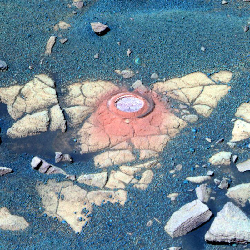
Image credit: NASA/JPL-Caltech/Cornell
NASA’s Mars Exploration Rover Opportunity recently stopped to analyze an exposure of rock near “Beagle Crater,” on a target nicknamed “Baltra.” Nearly 100 sols, or Martian days, had passed since Opportunity had last analyzed one of the now-familiar rock exposures seen on the Plains of Meridiani. The rover ground a 3-millimeter-deep (0.12-inch-deep) hole in the rock using the rock abrasion tool on sol 893 (July 29, 2006) while stationed about 25 meters (82 feet) from the southwest rim of Beagle Crater.
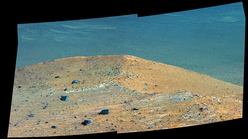
Image Credit: NASA/JPL-Caltech/Cornell/Arizona State Univ.
This scene from the panoramic camera (Pancam) on NASA’s Mars Exploration Rover Opportunity shows “Spirit Mound” overlooking the floor of Endeavour Crater. The mound stands near the eastern end of “Bitterroot Valley” on the western rim of the crater, and this view faces eastward.
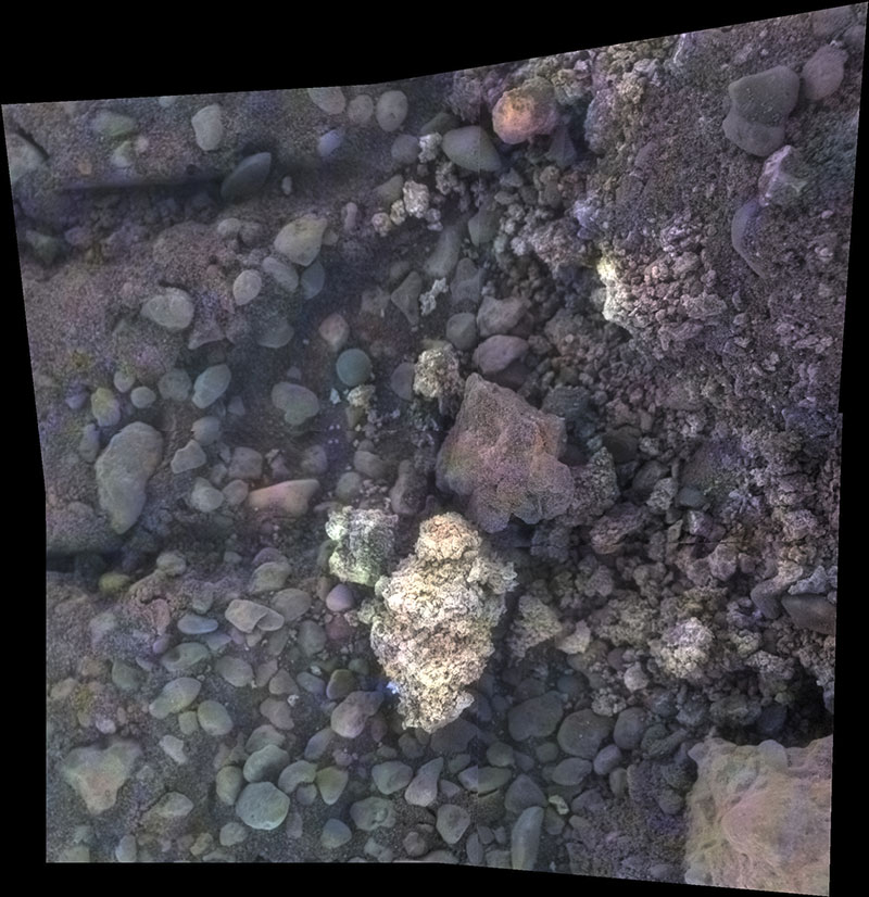
Image Credit: NASA/JPL-Caltech/Cornell/USGS/ASU
This image of a target called “Private Joseph Field” combines four images from the microscopic imager on the robotic arm of NASA’s Mars Exploration Rover Opportunity, with enhanced color information added from the rover’s panoramic camera.

Image Credit: NASA
In this image from 2010, Opportunity used its navigation camera for this northward view of tracks the rover left on a drive from one energy-favorable position on a sand ripple to another. The rover team called this strategy “hopping from lily pad to lily pad.”
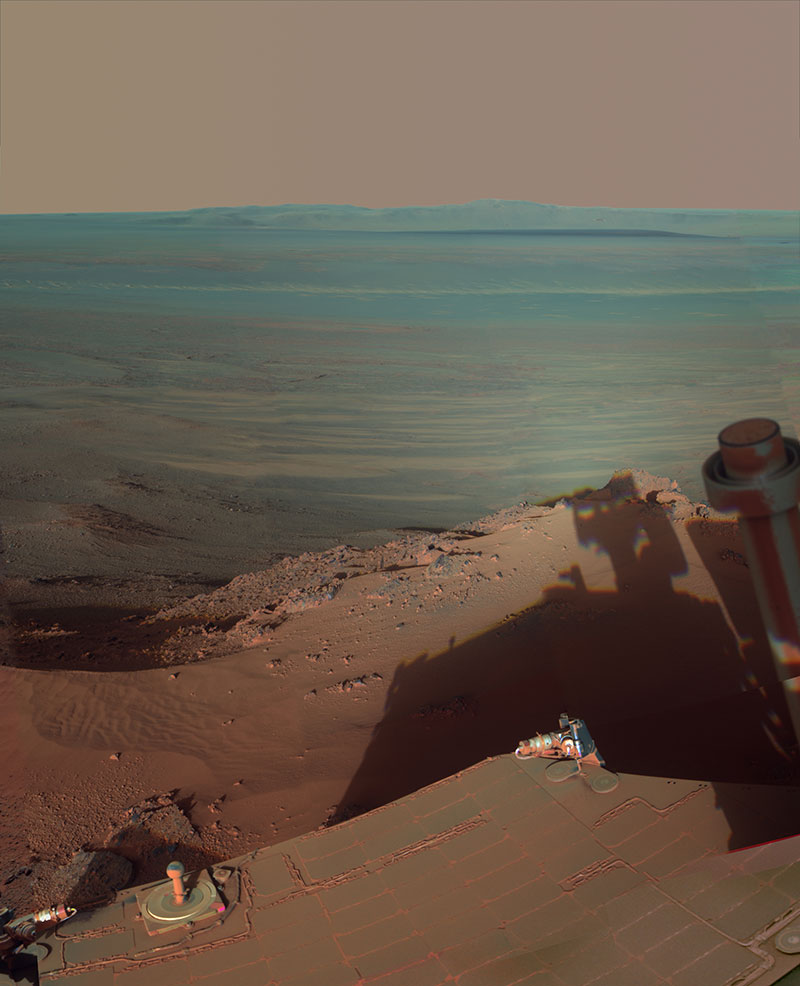
Image credit: NASA/JPL-Caltech/Cornell/Arizona State Univ.
NASA’s Mars Rover Opportunity catches its own late-afternoon shadow in this dramatically lit view eastward across Endeavour Crater on Mars. The rover used the panoramic camera (Pancam) between about 4:30 and 5:00 p.m. local Mars time to record images taken through different filters and combined into this mosaic view.
More Opportunity Achievements
– Set a one-day Mars driving record March 20, 2005, when it traveled 721 feet (220 meters).
– Returned more than 217,000 images, including 15 360-degree color panoramas.
– Exposed the surfaces of 52 rocks to reveal fresh mineral surfaces for analysis and cleared 72 additional targets with a brush to prepare them for inspection with spectrometers and a microscopic imager.
– Found hematite, a mineral that forms in water, at its landing site.
– Discovered strong indications at Endeavour Crater of the action of ancient water similar to the drinkable water of a pond or lake on Earth.


